UAS-Based Analysis of a Black Locust Clone Trial: Early Evaluation
doi: https://doi.org/10.5552/crojfe.2026.3906
volume: issue, issue:
pp: 15
- Author(s):
-
- Ábri Tamás
- Csajbók József
- Szabó Loránd
- Szabó Gergely
- Article category:
- Original scientific paper
- Keywords:
- black locust, UAS, multispectral, spectral indices, NDVI
Abstract
HTML
Black locust (Robinia pseudoacacia L.) is a key tree species globally and in Hungary, valued for its economic benefits, adaptability, and ecosystem services. Despite its invasiveness and susceptibility to frost damage, its high-quality timber and significant nectar production make it economically important. This research, conducted as a collaboration between the Hungarian Forest Research Institute and the University of Debrecen, aimed to evaluate the applicability of remote sensing technologies in supporting black locust (Robinia pseudoacacia L.) research and monitoring efforts. A clonal trial established in 2020 in eastern Hungary aimed to assess the performance of newly bred black locust clones. Tree height was measured using both conventional ground-based methods and photogrammetric analysis of unmanned aerial system (UAS) data, enabling comparison between the two approaches. Tree vitality was evaluated through UAS-based multispectral analysis using vegetation indices, including NDVI, GNDVI, NDRE, and LCI. Our findings revealed no significant differences (p>0.05) between UAS-based and traditional height measurements, confirming UAS as a reliable tool. Clones »NK2« and »PL251« showed superior growth (height of 7.6 m and 7.4 m) and health, while »Üllői« cultivar performed the weakest (5.3 m). Strong correlations were found between some vegetation indices (NDRE and LCI) and tree heights (r=0.593 and r=0.587), emphasizing the potential of remote sensing in efficient forest management. This study highlights the value of integrating UAS technology in forestry, offering cost-effective, accurate and comprehensive data for improving black locust cultivation practices.
UAS-Based Analysis of a Black Locust Clone Trial: Early Evaluation
Tamás Ábri, József Csajbók, Loránd Szabó, Gergely Szabó
https://doi.org/10.5552/crojfe.2026.3906
Abstract
Black locust (Robinia pseudoacacia L.) is a key tree species globally and in Hungary, valued for its economic benefits, adaptability, and ecosystem services. Despite its invasiveness and susceptibility to frost damage, its high-quality timber and significant nectar production make it economically important. This research, conducted as a collaboration between the Hungarian Forest Research Institute and the University of Debrecen, aimed to evaluate the applicability of remote sensing technologies in supporting black locust (Robinia pseudoacacia L.) research and monitoring efforts. A clonal trial established in 2020 in eastern Hungary aimed to assess the performance of newly bred black locust clones. Tree height was measured using both conventional ground-based methods and photogrammetric analysis of unmanned aerial system (UAS) data, enabling comparison between the two approaches. Tree vitality was evaluated through UAS-based multispectral analysis using vegetation indices, including NDVI, GNDVI, NDRE, and LCI. Our findings revealed no significant differences (p>0.05) between UAS-based and traditional height measurements, confirming UAS as a reliable tool. Clones »NK2« and »PL251« showed superior growth (height of 7.6 m and 7.4 m) and health, while »Üllői« cultivar performed the weakest (5.3 m). Strong correlations were found between some vegetation indices (NDRE and LCI) and tree heights (r=0.593 and r=0.587), emphasizing the potential of remote sensing in efficient forest management. This study highlights the value of integrating UAS technology in forestry, offering cost-effective, accurate and comprehensive data for improving black locust cultivation practices.
Keywords: black locust, UAS, multispectral, spectral indices, NDVI
1. Introduction
Black locust (Robinia pseudoacacia L.) is one of the most important tree species globally and also in Hungary because of its positive economic impacts, adaptability to many sites and climates, and ecosystem services such as landscape reclamation, carbon sequestration, and fuelwood. Its high-quality timber, valued for construction due to its durability and resistance to decay, and its production of high-value acacia honey, which is a significant income source for beekeepers, make it economically important. Additionally, its strong root system helps prevent soil erosion, and its ability to fix atmospheric nitrogen improves soil fertility, benefiting subsequent plant growth. It has great importance in China, South Korea, Italy, Germany, Romania, Bulgaria, Poland, and Hungary (Keresztesi 1988, Nicolescu et al. 2020, Ciuvăț et al. 2022, Ábri et al. 2023a). It covers 24% of the Hungarian stock area and it provides 19% of the annual timber output of the country (NLC 2022). After its introduction in the early 1700s, this fast-growing, relatively drought-tolerant, nitrogen-fixing tree species spread and became widely popular because of its valuable and resistant wood and its excellent nectar production (Keresztesi 1988, Nicolescu et al. 2018). However, it should be noted that Robinia has several disadvantages, both from ecological and growing technological (wood processing) perspective. Black locust is considered an invasive tree species, and its negative effects on the environment – changes in the light regime, microclimate, and soil conditions – are well known and can be found in many studies (Vítková et al. 2015, Sádlo et al. 2017, Vítková et al. 2017). Besides its invasiveness, it is susceptible to frost damage, and it often has curved and forked stems, which are disadvantageous for cultivation and the processability of wood (Nicolescu et al. 2020).
In Hungary, forestry research to increase the yield and nectar production of black locust and to improve its stem quality has been ongoing for decades. The black locust breeding program was initiated in the 1960s by the researchers of the Hungarian Forest Research Institute (FRI). Béla Keresztesi and his co-workers selected several plus trees and tree groups of the »ship mast« stem form in local stands. As a result, several state-approved cultivars with names referring to their place of selection appeared (e.g. »Üllői«, »Nyírségi«, »Kiskunsági«, »Jászkiséri«) (Keresztesi 1988, Nicolescu et al. 2018, Ábri et al. 2023a). The FRI recognized the need for new cultivars in the 1990s, when Károly Rédei continued the selection work of Keresztesi. During this period, attention was focused not only on good stem form but also on rapid juvenile growth and drought tolerance. This work resulted in five new candidate cultivars such as »Vacsi«, »Oszlopos«, »Homoki«, »Bácska«, and »Szálas«. The results of these research works can be found in several publications (Rédei et al. 2008 and 2013, Ábri et al. 2023a).
Currently, a joint project of the FRI and the Napkori Erdőgazdák ltd. is studying and testing the growing technology of black locust in industrial tree plantations and new high-performance black locust clones with high yields of industrial wood. In this project, the selection of excellent black locust trees with good characteristics and their further propagation under operational conditions by vegetative propagation is being developed, and testing of these clones in a clone trial is being carried out. Thus, industrial tree plantations are expected to play a key role in future forest management strategies. In addition to meeting the demand for quality timber, particularly for pile wood, black locust also has a positive environmental impact. It reduces the ecological pressures of harvesting native forests and helps the maintenance of natural forest ecosystems (Ábri et al. 2023b).
To obtain more information on newly selected clones, it is essential to establish experimental plantations (clonal trials). These trials should evaluate plant health and physiological parameters, including assimilation and transpiration rates, and water use efficiency alongside the traditional field measurements of height and thickness (Ábri et al. 2022, Ábri et al. 2023b). Field surveys are time- and labor-intensive processes. These measurements and plant health assessments could be replaced/supplemented by the analysis of Uncrewed Aerial System (UAS) imagery, which is increasingly used in the forestry and agriculture sectors (Wallace et al. 2016, Carl et al. 2017, Torresan et al. 2017, Peña et al. 2018, Burkhart et al. 2018, D'Odorico et al. 2021, Theofanous et al. 2021, Chandrasekaran et al. 2022, Ecke et al. 2022).
Tree height can be measured using photogrammetry, which provides a relatively low-cost alternative to LiDAR. (Næsset 2002, Lisein et al. 2013, Tang and Shao 2015, Krause et al. 2019, Moe et al. 2020, Guerra-Hernández et al. 2018, Guerra-Hernández et al. 2019, Tupinambá- Simões et al. 2022).
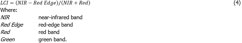
Vegetation indices (VIs), such as the Normalized Difference Vegetation Index (NDVI), Green Normalized Difference Vegetation Index (GNDVI), Normalized Difference Red Edge Index (NDRE), and Leaf Chlorophyll Index (LCI), have been developed for the qualitative and quantitative evaluation of vegetation cover, plant health, and growth dynamics using spectral measurements (Xue and Su 2017).
However, no such studies have yet been conducted on black locust plantations. Therefore, the examination of parameters in our research, including the surface area of the experimental site, the height of the clones, and vegetation indices (such as NDVI, GNDVI, NDRE, and LCI) reflecting their abiotic stress tolerance and health status, can be considered as a research gap.
The aim of this joint research project of the University of Debrecen (Institute of Crop Sciences and Institute of Earth Sciences) and FRI (University of Sopron) is to develop a method to replace time- and labor-intensive field inventories. In addition, obtaining information on tree growth, ecological needs, and health status (plant physiological parameters and vegetation indices) will help to select the most suitable tree/species for the given ecological conditions.
Our study aims to achieve the following objectives:
- investigate the correlation between photogrammetric height measurements and traditional methods (levelling staff, hypsometers)
- compare clone heights and identify significant differences among them
- determine vegetation indices ( NDVI , GNDVI , NDRE , and LCI ) and assess potential differences among the clones
- explore potential relationships between clone height and vegetation indices.
2. Methods
2.1 Study Area
The clone trial, which also serves as an experimental industrial tree plantation, was established in 2020 (Fig. 1). Covering a 2.66 ha site, we planted four vegetatively propagated, newly bred clones (»Püspökladányi« with breeding sign »PL251«, »Farkasszigeti« with breeding sign »PL040«, »Laposi« with breeding sign »NK1«, »Napkor« with breeding sign »NK2«); currently these are candidate cultivars (Ábri et al. 2023a). Additionally, we included a state-approved cultivar, called »Üllői« black locust as a control in 3 planting spacings (2.5×2.5 m, 3×3 m and 4×4 m). Notably, in 2021, in accordance with new regulations, the 3×3 m, and 4×4 planting spacings were modified to 3x1 m and 4x1 m (Ábri et al. 2023b).
Fig. 1 Orthophoto of the experimental plantation at Napkor (16th August 2023). Numbers indicate the clones (1: »PL251«, 2: »NK1«, 3: »PL040«, 4: »NK2«, 5: »Üllői«), and the letters indicate the planting spacings (a: 2.5×2.5 m, b: 3×3 m, c: 4×4 m)
The experimental plantation is located in Eastern Hungary, in the region called Nyírség (one of the best sites for growing black locust in the country), near the settlement of Napkor. The 20-year (2002–2021) average annual temperature is 10.9 °C and the average annual precipitation is 550.6 mm (the results section details the meteorological data for the period September 2022 to August 2023).
Based on the results of our soil analysis, the soil of the site is humus sandy soil with low humus (soil organic matter) content (SOM %<1) and slightly acidic conditions (pHKCl 5.17–5.34), classified as an arenosol according to the USDA soil taxonomy (Ábri et al. 2022).
From June 2022 to August 2023, soil moisture measurements were carried out using Delta-T PR2/6-SDI-12 profile probe (Delta-T Devices Ltd, UK) with 6 sensors (10, 20, 30, 40, 60, 100 cm depth) connected to the HH2 Moisture meter.
2.2 Digital Terrain Model and Tree Height Measurements
An aerial survey of the area was conducted in February 2022 using a DJI Phantom 4 UAS applying 60 m flight altitude with a Ground Sampling Distance (GSD) of 1.6 cm/pixel. During the survey, 248 images of the area were taken. The images were processed using Agisoft Metashape 2.0 (Agisoft) software to create a point cloud of the surface, which included both ground points and points representing objects like trees. Since our focus was the height of the surface, to produce a Digital Terrain Model (DTM) with resolution 3.3 cm, we used the automatic point cloud classifier in Metashape to filter out the non-ground points (e.g., trees). The remaining points represented only the ground surface, allowing us to generate a DTM of the area from this data. UTM-34N was selected as the coordinate reference system. For the projection transformation, 7 Ground Control Points (GCPs) were measured in the field applying a geodetic RTK GNSS receiver with ±4 cm accuracy.
Next, aerial images were taken during the growing season (leaf-on status) in June 2022 and August 2023. Aerial imagery was obtained from a 60 m flight altitude with 1.6 cm GSD, and a total of 882 images were captured per flight. Compared to the previous flight, more aerial images were taken because the tree canopy considerably obscured the surface and came into contact with adjacent foliage. These images were used to create a Digital Surface Model (DSM), where the tree canopy was clearly detectable. For georeferencing, the previously established method was applied. By subtracting the initial state (in February) elevation model from the later surface model, we obtained a normalized DSM (nDSM), the relative heights of the objects (i.e., trees) on the surface. The overall georeferencing error (Root Mean Square Error, RMSE) was approximately 1 cm in both cases (0.7 cm in February 2022, 1.3 cm in June 2022).
Using ArcGIS 10.8 (ESRI 2024) software we looked for the local maxima in the nDSM to automatically detect each tree (2207). Since the highest point of the tree canopy was not always exactly in the middle, these patches were irregular-shaped. The patches were vectorized, and then a circle of 80 cm diameter was placed on the centroid of each patch, ensuring that the highest detail of each tree was within the circle. The highest values were retrieved from the area of each circle using zonal statistics, providing the maximum height of each tree.
As some of the originally planted trees died, the owner also planted replacement trees. Therefore, trees with less than 2 m maximum height were excluded from the final model. In addition, the software was unable to process the tree canopy properly for several individuals; therefore, some of the trees were not detected in the nDSM. Further investigations are needed in this respect, particularly regarding the optimal resolution of the images of the canopy.
the height of the trees was also measured with a regular levelling rod, and two hypsometers, the Vertex IV (Haglöf) (Hypsometer 1) and the Forestry Pro II (Nikon) (Hypsometer 2) (Laar and Akca 2007) for comparison with the nDSM of the UAS survey. For this comparison, we randomly selected 30 trees and carried out height measurements with the three tools mentioned above and the nDSM values. After confirming (in agreement with previous studies e.g. Moe et al. 2020) the strong correlation between data from the field and from UAS models, we compared the clones by height in August 2023 (Fig. 2).
Fig. 2 Flowchart of image processing
2.3 Vegetation Indices
Multispectral orthophotos of the clone trial were collected using a MicaSense RedEdge-MX RED multispectral sensor mounted on a DJI M200 UAS (Janoušek et al. 2021) on 16th August 2023. Before and after the flight, calibrations were performed using a calibration panel. During the flight, 330 images were taken from a 60 m flight altitude with 6 cm GSD (Table 1).
Table 1 Key parameters of aerial photography
The spectral resolution of the sensor covered the following five spectral bands (Blue, Green, Red, Red Edge and Near Infrared). We processed the images using the Agisoft Metashape 2.0 software, and calculated NDVI (Eq. 1, Rouse et al. 1974), GNDVI (Eq. 2, Gitelson et al. 1996), NDRE (Eq. 3, Gitelson and Merzylak 1994) and LCI (Eq. 4, Datt 1999) vegetation indices from the spectral bands using the following equations:


2.4 Statistical Analysis
First, we exported the obtained data to MS Excel 2016. For the comparison of the different height measurements conducted on 16th June 2022, 30 sample trees were selected. Statistics were performed in pairs, that is, levelling rod vs. UAS-based height, Hypsometer 1 vs. UAS-based height, and Hypsometer 2 vs. UAS-based height. We also compared the levelling rod with Hypsometer 1, levelling rod with Hypsometer 2, and Hypsometer 1 with Hypsometer 2. Our data were non-parametric, based on the Shapiro-Wilk test. The Kruskal-Wallis H test was used for comparison. The Spearman correlation coefficient (r) was calculated to assess the degree of association between pairs. Linear regression data from the levelling rod and UAS data are also presented.
The clones were compared by height and by the four vegetation indices. The data were from 30 randomly selected trees per clone per planting spacing, but in case of the comparison of VIs values, we used data from planting spacing 2.5×2.5 m (n=30 sample trees per clones). For statistical analysis, Fisher's Least Significant Difference (LSD) and Games-Howell post-hoc tests were used. The correlations between height and VIs data (n=450, 30 randomly selected trees per clones per planting spacing) were also analyzed. For this purpose, Spearman’s correlation was used. Statistical analysis was carried out using MS Excel 2016 and IBM SPSS 25.0 statistical software package.
3. Results
3.1 Results of Soil Moisture Measurements Related to Meteorological Data
Analyzing the data from the Nyíregyháza-Napkor meteorological station, it can be stated that the autumn-winter period 2022–2023 was very variable in terms of rainfall. There was 88.4 mm more precipitation in September 2022 than the 20-year average. This contributed to soil water recharge in soils with good water holding capacity, but on sandy soils with low water holding capacity in the experimental area, it has infiltrated into the groundwater. The following month, October, however, was very dry, with only 8.4 mm of precipitation, 36.3 mm less than the 20-year average. November rainfall was around average, followed by December and January with rainfall well above average (54.7 and 36.6 mm, respectively). February was again dry, with 23 mm below the 20-year average (Fig. 3).
Spring started with slightly above average precipitation (March: +13.1, April: +4.3 mm), but May was dry, with 28.9 mm below the 20-year average, which was unfavourable for the initial growth of black locust. June and August were rainy, with 44.1 and 30.5 mm above 20-year average precipitation, respectively.
An analysis of the temperature data shows that the average temperature for the period September 2022 to August 2023 was 0.8 °C above the 20-year average. The monthly average temperature was below the 20-year average only in September, April and June, by 1.2, 2.2 and 0.8 °C, respectively.
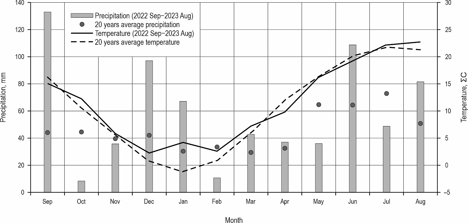
Fig. 3 Precipitation and temperature data of the experiment site (September 2022−August 2023, Napkor)
The results of the soil moisture measurements are shown in Fig. 4. The figure clearly shows that the soil moisture data follow the course of precipitation with a small time lag, which is obviously related to the water consumption of the black locust. The temporal shift helped the plants during the shorter dry periods, although the soil in the experiment cannot be classified as a soil with good water management and good water-holding capacity.
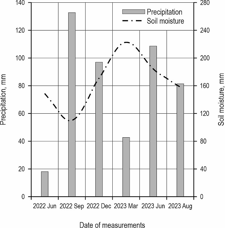
Fig. 4 Soil moisture content and precipitation data between June 2022 and August 2023 (Napkor)
3.2 DTM of the Experimental Field
As shown in Fig. 5, the study area shows different elevations of the sand dunes found here. The difference between the lowest and highest points is 4 m.
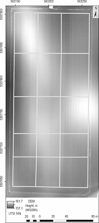
Fig. 5 Digital Terrain Model of the study area
Fig. 6 shows the heights of the trees calculated by photogrammetry. The 5 different clones in 3 planting spacings (in total 15 plots) already show characteristic differences in height. This is most visible for the 3 southernmost planting spaces. The tallest trees reached approximately 8 m at the time of measurement.
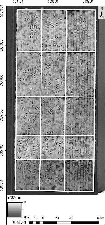
Fig. 6 Normalized Digital Surface Model of the study area with sample trees (n=450), 16th August 2023, Napkor
3.3 Comparison of Height Measurement Tools
The observed tree heights of the 30 sample trees are shown in Table 2. The minimum heights were measured using a UAV and Hypsometer 2. The maximum value was measured with Hypsometer 1. The ranges are 1.55 m (levelling rod), 1.50 m (Hypsometer 1 and Hypsometer 2), 1.20 m (UAV).
Table 2 Observed tree height from field (levelling rod, Hypsometer 1, Hypsometer 2) and from UAS. Result of Kruskal-Wallis H test. Results are significant at p=0.05 (30th June 2022)
|
n |
Mean height m |
SD |
Min. height m |
Max. height m |
|
|
Levelling rod |
30 |
4.28a |
±0.34 |
3.40 |
4.95 |
|
Hypsometer 1 |
30 |
4.40ab |
±0.38 |
3.60 |
5.10 |
|
Hypsometer 2 |
30 |
4.13ac |
±0.37 |
3.20 |
4.70 |
|
UAS |
30 |
4.03ac |
±0.35 |
3.20 |
4.40 |
|
n – number of samples, SD – Standard Deviation, small letters indicate significant differences between the measurements |
|||||
As a result of the Kruskal-Wallis test, significant differences were found only between Hypsometer 1 (4.40±0.38 m) and Hypsometer 2 (4.13±0.37 m), and UAV (4.03±0.35 m) and Hypsometer 1. Therefore, there is no significant difference between the UAV and levelling rod (4.28±0.34 m), and the UAV and Hypsometer 2.
We found a strong correlation between the UAV-based height result and levelling rod measurements (r=0.758) and medium correlation between the UAV-based height result and hypsometers (r>0.619), which was significant at p=0.01 (Table 3). Furthermore, the linear regression function fitted well with the measured data points, with an R2 value of 0.7436 (Fig. 7).
Table 3 Correlation of tree height derived from field (levelling rod, Hypsometer 1–2) and UAV data for 30 sample trees. The correlation is significant at p=0.01 level
|
Levelling rod |
Hypsometer 1 |
Hypsometer 2 |
UAV |
|
|
Levelling rod |
1.000 |
0.821a |
0.811a |
0.758 a |
|
Hypsometer 1 |
– |
1.000 |
0.876 a |
0.619 b |
|
Hypsometer 2 |
– |
– |
1.000 |
0.629 b |
|
UAV |
– |
– |
– |
1.000 |
|
a – indicates strong correlation, b – indicates medium correlation |
||||
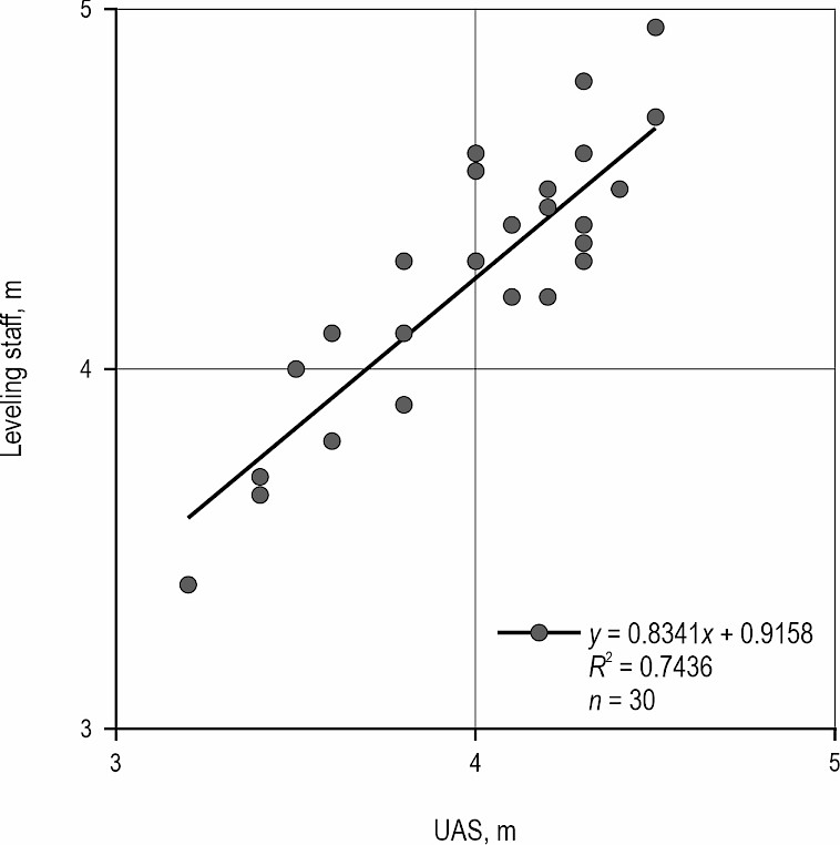
Fig. 7 Linear regression between data from levelling rod and UAS measurements
3.4 Comparison of Clones by UAS Height Measurements
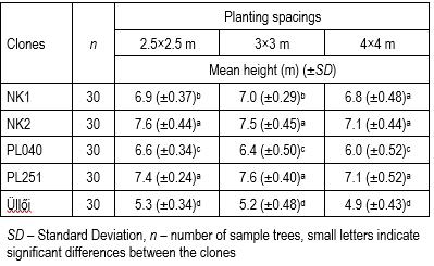
We compared the clones (n=30 per clones per planting spacings, 16th August 2023) based on their height values applying Fisher's Least Significant Difference (LSD) test. As shown in Table 4, there were significant differences between the clones tested. The best clones were »NK2« (7.1–7.6 m) and »PL251« (7.1–7.6 m), while the »Üllői« black locust cultivar was the weakest (4.9–5.3 m). However, there were no significant differences between clones »NK1«, »NK2« and »PL251« in planting spacing 4×4 m. Additionally, »NK1« was the third highest clone after »NK2« and »PL251«.
Table 4 Comparison of clones by UAV height measurement (Results of Fisher's Least Significant Difference test), p=0.05, 16th August 2023, Napkor
3.5 Vegetation Index Assessment
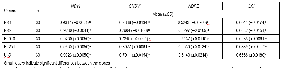
Vegetation indices provide an overview of the current state of the clones. From the obtained values, we inferred the biomass yield, nutrient supply, and health status of the trees. NDVI, GNDVI, NDRE, and LCI were calculated from the multispectral UAS survey. Pairwise comparisons (Games-Howell test) showed significant (p=0.05) differences between the clones. The clones showed very high NDVI values. For all VIs, »PL251« was the best performing clone (NDVI: 0.9360±0.0050, GNDVI: 0.8027±0.0091, NDRE: 0.5530±0.0134 and LCI: 0.6889±0.0117), but was not significantly different from »NK1« based on the NDVI (0.9347±0.0051) and »NK2« based on the GNDVI (0.7964±0.0106) at the 5% significance level. »PL040« was the weakest among all tested indicators, with an NDVI of 0.9260±0.0050, GNDVI of 0.7849±0.0064, NDRE of 0.5137±0.0110 and LCI of 0.6536±0.0091. Only the clone »PL251« significantly (p=0.05) outperformed the NDRE and LCI index values of the control cultivar »Üllői« (NDRE: 0.5140±0.0214, LCI: 0.6566±0.0180). The last two VIs are more sensitive to photosynthetic activity and chlorophyll content because of the use of the Red Edge wavelength (Table 5).
Table 5 Comparison of clones by vegetation indices in planting space 2.5×2.5 m. Results of the Games-Howell test (p = 0.05), 16th August 2023, Napkor
Correlations between the height and VIs of the clones were tested using Spearman's correlation. As shown in Table 6, strong correlations (significant at p=0.01 level) were found between GNDVI and NDRE (r=0.900), GNDVI and LCI (r=0.908), as well as between LCI and NDRE (r=0.988). There were medium correlations between NDVI and GNDVI (r=0.512), NDVI and NDRE (r=0.562), as well as between NDVI and LCI (r=0.613). In addition, medium correlations were found between height and NDRE (r=0.593) as well as between height and LCI (r=0.587) values. Weak relationships were found between height and GNDVI (r=0.406), and height and NDVI (r=0.232).
Table 6 Correlation of tree height and vegetation indices (NDVI, GNDVI, NDRE and LCI) data for 450 sample trees (30 per clones per planting spacings). 16th August 2023, Napkor. Based on measured data from 450 sample trees (n=450). The correlation is significant at p=0.01 level
|
Height |
NDVI |
GNDVI |
NDRE |
LCI |
|
|
Height |
1.000 |
0.232c |
0.406c |
0.593b |
0.587b |
|
NDVI |
– |
1.000 |
0.512b |
0.562b |
0.613b |
|
GNDVI |
– |
– |
1.000 |
0.900a |
0.908a |
|
NDRE |
– |
– |
– |
1.000 |
0.988a |
|
LCI |
– |
– |
– |
– |
1.000 |
|
a – indicates strong correlation, b – indicates medium correlation c – indicates weak correlation |
|||||
4. Discussion
4.1 UAS-based Tree Height Measurement
Tree height is a fundamental measure in forestry and tree plantations, related to above-ground dendromass and the vertical structure of the tree canopy. It is widely used to assess site productivity, timber quality, and forest ecosystem services, including protection against natural hazards and biodiversity (De Petris et al. 2022). Several studies have demonstrated the applicability of UAS-based height measurements (Wallace et al. 2016, Krause et al. 2019, Moe et al. 2020). Our comparison of field survey data (using levelling rods and hypsometers) with UAS-based imagery showed no significant differences, with a high R² value of 0.7436. Additionally, UAS-measured heights revealed significant differences among clones, with clones »NK2« and »PL251« showing the best results (7.1–7.6 m), while the state-approved cultivar »Üllői« had the lowest values (4.9–5.3 m) across three planting spacings. These trends align with previous field surveys (Ábri et al. 2022, Ábri et al. 2023b).
4.2 Vegetation Indices – Importance, Use, Spectral Sensitivity, Correlations
VIs are crucial for monitoring vegetation cover, growth dynamics, and tree health (Xue and Su 2017, Dash et al. 2018, Guerra-Hernández et al. 2021, Duarte et al. 2022, Ecke et al. 2022). The NDVI, ranging from –1 to 1, is the most widely used VI, indicating the health and photosynthetic activity of vegetation, with values between 0.66 and 1 considered very good (Rouse et al. 1974). The GNDVI, an alternative to NDVI, uses the green band instead of the red band, providing a wider dynamic range and more sensitive chlorophyll content recording (Gitelson et al. 1996). NDRE and LCI are also alternatives to NDVI, offering more accurate chlorophyll content estimates (Gitelson et al. 2005, Jorge et al. 2019, Vivar-Vivar et al. 2022). Our study found significant differences in the four VIs among the clones. Clone »PL251« had the highest NDVI (0.9360) and clone »PL040« the lowest (0.9260), indicating that all clones were in very good health. GNDVI results were similar, with the highest value for »PL251« (0.8027) and the lowest for »PL040« (0.7849). NDVI and GNDVI values suggested excellent conditions for all clones. »PL251« also had the best NDRE (0.5530) and LCI (0.6889) values. The general differences between the values (NDVI–NDRE, NDVI–LCI) were caused by the higher reflectance in the infrared range (Jurado et al. 2020). The study of Huete et al. (1997) concluded that vegetation indices with higher weighting coefficients in the near-infrared range are the most effective for enhancing performance over forested and densely vegetated canopies. Zhang et al. (2022) also highlight that next to regular spectral indices, other parameters have to be used to obtain a more complex view. In agreement with these studies, we involved several additional spectral indices, such as GNDVI, NDRE, LCI and also tree height parameter. NDVI values correlate with rainfall (Liu et al. 2019, Mangewa et al. 2022), suggesting good drought tolerance and recovery capability of clones after the dry year of 2022 (Ábri et al. 2023b). The highest clone, »PL251«, also had the highest VI values, particularly NDRE and LCI, related to the other clones, indicating higher chlorophyll content, possibly in response to heat stress (Li et al. 2018, Húdoková et al. 2022). We agree that NDVI is one of the most important VI by its potential to qualify different vegetation types, along with the study of Ye et al. (2021), where NDVI was the second most important variable in estimating aboveground biomass. The versatility and potential of VIs remain evident. The broad range of applications emphasizes the vast potential of these indices to contribute to our understanding and management of agricultural and forestry systems. Moving forward, continued exploration and adaptation of VIs will undoubtedly yield even more profound insights and practical applications (Vélez et al. 2023).
Jorge et al. (2019) found a strong relationship between NDVI and GNDVI but a poor relationship between NDVI and NDRE, and GNDVI and NDRE. Our study confirmed strong correlations between GNDVI and NDRE (r=0.900), GNDVI and LCI (r=0.908), and NDRE and LCI (r=0.988). We also observed a moderate correlation between height and NDRE (r=0.593) and height and LCI (r=0.587). These findings highlight the efficiency of measuring red edge and near-infrared wavelengths in juvenile black locust plantations to estimate quality parameters and compare different clones. However, this requires a more expensive sensor compared to a simple RGB camera, which is sufficient for cost-effective tree height measurement, reducing remote sensing inventory analysis costs.
4.3 Economic and Practical Importance of UAS-based Surveys
In the face of climate change, the economic importance of remote sensing methods, such as UAS-based surveys, for monitoring forests and tree plantations is imperative for the development of agroforestry systems (Guimarães et al. 2020). Studies have shown that user uptake of remote sensing approaches can be slow or absent even when suitable technological solutions exist (Fassnacht et al. 2024). According to Matese et al. (2015), multicopter UASs such as DJI Phantom 4 and DJI M200, which were used in our study, proved to be the most cost-effective solution for monitoring small fields (<5 ha) up to 50–60 ha or larger areas. Furthermore, UASs can host a wide range of task-oriented sensors, provide on-demand data availability, enable planning data acquisition campaigns to avoid poor weather conditions, and can be used in real-time operations (Guimarães et al. 2020). Zhao et al. (2020) also highlighted the potential of using UASs for forest quality assessment.
4.4 Limitations and Challenges
Despite promising results, there were some limiting factors, such as leaf optical properties, soil reflectance, canopy structure, sun direction, and sensor effects, all of which are important factors governing spectral accuracy (Asner 1998, Vivar-Vivar et al. 2020). In recent decades, spectral analysis has undergone significant advancements, allowing for much more accurate stand surveys with the aid of newly developed vegetation indices (VIs). We are now able to correct many previously limiting factors. However, there is still a lack of precise rule frameworks that contributes to tedious requests for flight permissions. One of the most severe limitations associated with the use of UASs is that it is difficult to fully cover forests on a large scale (Guimarães et al. 2020).
5. Conclusions
Black locust is a fast-growing, relatively drought-tolerant, and multipurpose tree species. Its economic potential is mainly in Central-Eastern European countries such as Hungary, Romania, and Poland. In some Asian countries (China and South Korea), it plays a crucial role in the afforestation of marginal sites (eroded sites and denuded mountains) (Nicolescu et al. 2020).
The ongoing breeding and research efforts by the Hungarian Forest Research Institute (University of Sopron) have aimed to enhance its stem quality, drought tolerance, and rapid juvenile growth, resulting in several promising clones and cultivars. Some of these clones are being studied in a joint project with the University of Debrecen.
The application of Uncrewed Aerial Systems (UAS) in this research has proven to be a valuable tool for assessing tree height and vegetation indices, offering a cost-effective and efficient alternative to traditional field measurements. The study found strong correlations between UAS-based height measurements and conventional methods, indicating the reliability of this technology.
In a clone trial, near the settlement of Napkor, among the tested clones, »NK2« and »PL251« exhibited the best growth and health metrics, including significant differences in tree height and vegetation indices such as NDVI, GNDVI, NDRE, and LCI. These indices provide crucial insights into the biomass yield, nutrient supply, and overall health of the trees (Ecke et al. 2022), with clone »PL251« consistently performing the best. Due to the characteristic foliage-development of black locust, automatic and semi-automatic testing methods are often not optimal, so the testing of this species is of great importance in the future.
Overall, the integration of advanced remote sensing technologies with traditional forestry practices offers a promising pathway for improving black locust cultivation and management, ultimately supporting both economic and environmental goals in the face of climate change and other challenges.
Acknowledgments
This article was prepared within the frame of the project TKP2021-NKTA-43, which has been implemented with the support provided by the Ministry of Culture and Innovation of Hungary from the National Research, Development and Innovation Fund, financed under the TKP2021-NKTA funding scheme. The research was further supported by the National Research, Development and Innovation Office (NKFI Office) under grants NKFI K 138079 and NKFI ADVANCED 152950.
The authors express their gratitude to the local private forest company (Napkori Erdőgazdák Ltd.) for their valuable support in the field. The laboratory of the Forest Research Institute is also acknowledged for the soil analysis. In addition, our colleagues are thanked for their help with the fieldwork and assistance. Finally, we are also grateful to the reviewers for their valuable and constructive criticism.
Conflicts of Interest
For research articles with several authors, a short paragraph specifying their contributions must be provided. The following statements should be used »T.Á. conceived and designed the experiments; T.Á., J.C. and G.S. performed the experiments; J.C. and T.Á. analysed the data; G.S. and L.S. contributed reagents/materials/analysis tools; T.Á., J.C., G.S. and L.S. wrote the paper«. Authorship must be limited to those who have contributed substantially to work reported.
6. References
Ábri, T., Keserű, Z., Borovics, A., Rédei, K., Csajbók, J., 2022: Comparison of juvenile, drought tolerant black locust (Robinia pseudoacacia L.) clones with regard to plant physiology and growth characteristics in Eastern Hungary: early evaluation. Forests 13(2): 292. https://doi.org/10.3390/f13020292
Ábri, T., Cseke, K., Keserű, Z., Porcsin, A., Szabó, F.M., Rédei, K., 2023a: Breeding and improvement of black locust (Robinia pseudoacacia L.) with a special focus on Hungary: a review. iForest 16: 290–298, https://doi.org/10.3832/ifor4254-016
Ábri, T., Borovics, A., Csajbók, J., Kovács, E., Koltay, A., Keserű, Z., Rédei, K., 2023b: Differences in the Growth and the Ecophysiology of Newly Bred, Drought-Tolerant Black Locust Clones. Forests 14(9): 1802. https://doi.org/10.3390/f14091802
Agisoft: Available online: https://www.agisoft.com/ (accessed 8 August 2024)
Asner, G.P., 1998: Biophysical and biochemical sources of variability in canopy reflectance. Remote Sens. Environ. 64(3): 234–253. https://doi.org/10.1016/S0034-4257(98)00014-5
Burkhart, H.E., Avery, T.E., Bullock, B.P., 2018: Forest measurements, 6th ed.; Waveland Press: Long Grove, Illinois, USA, 438 p.
Carl, C., Landgraf, D., Van der Maaten-Theunissen, M., Biber, P., Pretzsch, H., 2017: Robinia pseudoacacia L. flowers analyzed by using an unmanned aerial vehicle (UAV). Remote Sens. 9(11): 1091. https://doi.org/10.3390/rs9111091
Chandrasekaran, A., Shao, G., Fei, S., Miller, Z., Hupy, J., 2022: Automated Inventory of Broadleaf Tree Plantations with UAS Imagery. Remote Sens. 14(8): 1931. https://doi.org/10.3390/rs14081931
Ciuvăț, A.L., Abrudan, I.V., Ciuvăț, C.G., Marcu, C., Lorenț, A., Dincă, L., Bartha, S., 2022: Black locust (Robinia pseudoacacia L.) in Romanian forestry. Diversity 14(10): 780. https://doi.org/10.3390/d14100780
Dash, J.P., Pearse, G.D., Watt, M.S., 2018: UAV multispectral imagery can complement satellite data for monitoring forest health. Remote Sens. 10(8): 1216. https://doi.org/10.3390/rs10081216
Datt, B., 1999: A new reflectance index for remote sensing of chlorophyll content in higher plants: tests using Eucalyptus leaves. J. Plant Physiol. 154(1): 30–36. https://doi.org/10.1016/S0176-1617(99)80314-9
De Petris, S., Sarvia, F., Borgogno-Mondino, E., 2022: About Tree Height Measurement: Theoretical and Practical Issues for Uncertainty Quantification and Mapping. Forests 13(7): 969. https://doi.org/10.3390/f13070969
D’Odorico, P., Schönbeck, L.C., Vitali, V., Meusburger, K., Schaub, M., Ginzler, C., Zweifel, R., Velasco, V.M.E., Gisler, J., Gessler, A., Ensminger, I., 2021: Drone-based physiological index reveals long-term acclimation and drought stress responses in trees. Plant Cell Environ. 44(11): 3552–3570. https://doi.org/10.1111/pce.14177
Duarte, A., Borralho, N., Cabral, P., Caetano, M., 2022: Recent advances in forest insect pests and diseases monitoring using UAV-based data: A systematic review. Forests 13(6): 911. https://doi.org/10.3390/f13060911
Ecke, S., Dempewolf, J., Frey, J., Schwaller, A., Endres, E., Klemmt, H.J., Tiede, D., Seifert, T., 2022: UAV-based forest health monitoring: A systematic review. Remote Sens. 14(13): 3205. https://doi.org/10.3390/rs14133205
ESRI: Available online: https://www.esri.com/ (accessed 8 August 2024).
Fassnacht, F.E., White, J.C., Wulder, M.A., Næsset, E., 2024: Remote sensing in forestry: current challenges, considerations and directions. For. Int. J. For. Res. 97(1): 11–37. https://doi.org/10.1093/forestry/cpad024
Gitelson, A., Merzlyak, M.N., 1994: Spectral reflectance changes associated with autumn senescence of Aesculus hippocastanum L. and Acer platanoides L. leaves. Spectral features and relation to chlorophyll estimation. J. Plant Physiol. 143(3): 286–292. https://doi.org/10.1016/S0176-1617(11)81633-0
Gitelson, A.A., Kaufman, Y.J., Merzlyak, M.N., 1996: Use of a green channel in remote sensing of global vegetation from EOS-MODIS. Remote Sens. Environ. 58(3): 289–298. https://doi.org/10.1016/S0034-4257(96)00072-7
Gitelson, A.A., Viña, A., Ciganda, V., Rundquist, D.C., Arkebauer, T.J., 2005: Remote estimation of canopy chlorophyll content in crops. Geophys. Res. Lett. 32(8): L08403. https://doi.org/10.1029/2005GL022688
Guerra-Hernández, J., Cosenza, D.N., Rodriguez, L.C.E., Silva, M., Tomé, M., Díaz-Varela, R.A., González-Ferreiro, E., 2018: Comparison of ALS- and UAV (SfM)-derived high-density point clouds for individual tree detection in Eucalyptus plantations. Int. J. Remote Sens. 39(15–16): 5211–5235. https://doi.org/10.1080/01431161.2018.1486519
Guerra-Hernández, J., Cosenza, D.N., Cardil, A., Silva, C.A., Botequim, B., Soares, P., Díaz-Varela, R.A., 2019: Predicting growing stock volume of eucalyptus plantations using 3-D point clouds derived from UAV imagery and ALS data. Forests 10(10): 905. https://doi.org/10.3390/f10100905
Guerra-Hernández, J., Díaz-Varela, R.A., Álvarez-González, J.G., Rodríguez-González, P.M., 2021: Assessing a novel modelling approach with high resolution UAV imagery for monitoring health status in priority riparian forests. For. Ecosyst. 8: 61. https://doi.org/10.1186/s40663-021-00342-8
Guimarães, N., Pádua, L., Marques, P., Silva, N., Peres, E., Sousa, J.J., 2020: Forestry remote sensing from unmanned aerial vehicles: A review focusing on the data, processing and potentialities. Remote Sens. 12(6): 1046. https://doi.org/10.3390/rs12061046
Húdoková, H., Petrik, P., Petek-Petrik, A., Konôpková, A., Leštianska, A., Střelcová, K., Kmeť, J., Kurjak, D., 2022: Heat-stress response of photosystem II in five ecologically important tree species of European temperate forests. Biologia 77(3): 671–680. https://doi.org/10.1007/s11756-021-00958-9
Huete, A.R., Liu, H.Q., van Leeuwen, W.J.D., 1997: The use of vegetation indices in forested regions: issues of linearity and saturation. In: IGARSS '97. 1997 IEEE International Geoscience and Remote Sensing Symposium Proceedings. Remote Sensing – A Scientific Vision for Sustainable Development, Singapore, August 03–08, Vol. 4: 1966–1968. https://doi.org/10.1109/IGARSS.1997.609169
Huete, A., Didan, K., Miura, T., Rodriguez, E.P., Gao, X., Ferreira, L.G., 2002: Overview of the radiometric and biophysical performance of the MODIS vegetation indices. Remote Sens. Environ. 83(1–2): 195–213. https://doi.org/10.1016/S0034-4257(02)00096-2
Hungarian National Land Centre (NLC). Available online: https://nfk.gov.hu/Adatbazisok_linkjei___Erdeszet_news_305 (accessed on 12.12.2022).
Janoušek, J., Jambor, V., Marcoň, P., Dohnal, P., Synková, H., Fiala, P., 2021: Using UAV-based photogrammetry to obtain correlation between the vegetation indices and chemical analysis of agricultural crops. Remote Sens. 13(10): 1878. https://doi.org/10.3390/rs13101878
Jorge, J., Vallbé, M., Soler, J.A., 2019: Detection of irrigation inhomogeneities in an olive grove using the NDRE vegetation index obtained from UAV images. Eur. J. Remote Sens. 52(1): 169–177. https://doi.org/10.1080/22797254.2019.1572459
Jurado, J.M., Ortega, L., Cubillas, J.J., Feito, F.R., 2020: Multispectral mapping on 3D models and multi-temporal monitoring for individual characterization of olive trees. Remote Sens. 12(7): 1106. https://doi.org/10.3390/rs12071106
Keresztesi, B., 1988: The Black locust, Akadémia Kiadó: Budapest, Hungary, 197.
Krause, S., Sanders, T.G., Mund, J.P., Greve, K., 2019: UAV-based photogrammetric tree height measurement for intensive forest monitoring. Remote Sens. 11(7): 758. https://doi.org/10.3390/rs11070758
Li, Y., He, N., Hou, J., Xu, L., Liu, C., Zhang, J., Wang, Q., Zhang, X., Wu, X., 2018b: Factors influencing leaf chlorophyll content in natural forests at biome scale. Front. Ecol. Evol. 6: 64. https://doi.org/10.3389/fevo.2018.00064
Lisein, J., Pierrot-Deseilligny, M., Bonnet, S., Lejeune, P., 2013: A photogrammetric workflow for the creation of a forest canopy height model from small unmanned aerial system imagery. Forests 4(4): 922–944. https://doi.org/10.3390/f4040922
Liu, L., Wang, Y., Wang, Z., Li, D., Zhang, Y., Qin, D., Li, S., 2019: Elevation-dependent decline in vegetation greening rate driven by increasing dryness based on three satellite NDVI datasets on the Tibetan Plateau. Ecol. Indic. 107: 105569. https://doi.org/10.1016/j.ecolind.2019.105569
Mangewa, L.J., Ndakidemi, P.A., Alward, R.D., Kija, H.K., Bukombe, J.K., Nasolwa, E.R., Munishi, L.K., 2022: Comparative assessment of UAV and Sentinel-2 NDVI and GNDVI for preliminary diagnosis of habitat conditions in Burunge wildlife management area, Tanzania. Earth 3(3): 769–787. https://doi.org/10.3390/earth3030044
Matese, A., Toscano, P., Di Gennaro, S.F., Genesio, L., Vaccari, F.P., Primicerio, J., Gioli, B., 2015: Intercomparison of UAV, aircraft and satellite remote sensing platforms for precision viticulture. Remote Sens. 7(3): 2971–2990. https://doi.org/10.3390/rs70302971
Moe, K.T., Owari, T., Furuya, N., Hiroshima, T., 2020: Comparing individual tree height information derived from field surveys, LiDAR and UAV-DAP for high-value timber species in Northern Japan. Forests 11(2): 223. https://doi.org/10.3390/f11020223
Næsset, E., 2002: Determination of mean tree height of forest stands by digital photogrammetry. Scand. J. For. Res. 17(5): 446–459. https://doi.org/10.1080/028275802320435469
Nicolescu, V.N., Hernea, C., Bakti, B., Keserű, Z., Antal, B., Rédei, K., 2018: Black locust (Robinia pseudoacacia L.) as a multi-purpose tree species in Hungary and Romania: a review. J. For. Res. 29(6): 1449–1463. https://doi.org/10.1007/s11676-018-0626-5
Nicolescu, V.N., Rédei, K., Mason, W.L., Vor, T., Pöetzelsberger, E., Bastien, J.C., Brus, R., Benčať, T., Đodan, M., Cvjetkovic, B., Andrašev, S., La Porta, N., Lavnyy, V., Mandžukovski, D., Petkova, K., Roženbergar, D., Wąsik, R., Mohren, G.M.J., Monteverdi, M.C., Musch, B., Klisz, M., Perić, S., Keća, L., Bartlett, D., Hernea, C., Pástor, M., 2020: Ecology, growth and management of black locust (Robinia pseudoacacia L.), a non‑native species integrated into European forests. J. For. Res. 31(4): 1081–1101. https://doi.org/10.1007/s11676-020-01116-8
Peña, J.M., de Castro, A.I., Torres-Sánchez, J., Andújar, D., San Martín, C., Dorado, J., Fernández-Quintanilla, C., López-Granados, F., 2018: Estimating tree height and biomass of a poplar plantation with image-based UAV technology. AIMS Agric. Food 3(3): 313–326. https://doi.org/10.3934/agrfood.2018.3.313
Rédei, K., Osvath‑Bujtas, Z., Veperdi, I., 2008: Black locust (Robinia pseudoacacia L.) improvement in Hungary: a review. Acta Silv. Lign. Hung. 4(1): 127–132. https://doi.org/10.37045/aslh-2008-0011
Rédei, K., Keserű, Zs., Csiha, I., Rásó, J., Kamandiné Végh, Á., Antal, B., 2013: Juvenile growth and morphological traits of micropropagated black locust (Robinia pseudoacacia L.) clones under arid site conditions. Acta Silv. Lign. Hung. 9: 35–42. https://doi.org/10.2478/aslh-2013-0003
Rouse, J.W., Haas, R.H., Schell, J.A., Deering, D.W., 1974: Monitoring vegetation systems in the Great Plains with ERTS. NASA Spec. Publ. 351(1): 309.
Sádlo, J., Vítková, M., Pergl, J., Pyšek, P., 2017: Towards site-specific management of invasive alien trees based on the assessment of their impacts: the case of Robinia pseudoacacia. NeoBiota 35: 1–34. https://doi.org/10.3897/neobiota.35.11909
Tang, L., Shao, G., 2015: Drone remote sensing for forestry research and practices. J. For. Res. 26(4): 791–797. https://doi.org/10.1007/s11676-015-0088-y
Theofanous, N., Chrysafis, I., Mallinis, G., Domakinis, C., Verde, N., Siahalou, S., 2021: Aboveground Biomass Estimation in Short Rotation Forest Plantations in Northern Greece Using ESA’s Sentinel Medium-High Resolution Multispectral and Radar Imaging Missions. Forests 12(7): 902. https://doi.org/10.3390/f12070902
Torresan, C., Berton, A., Carotenuto, F., Di Gennaro, S.F., Gioli, B., Matese, A., Miglietta, F., Vagnoli, C., Zaldei, A., Wallace, L., 2017: Forestry applications of UAVs in Europe: A review. Int. J. Remote Sens. 38(8–10): 2427–2447. https://doi.org/10.1080/01431161.2016.1252477
Tupinambá-Simões, F., Bravo, F., Guerra-Hernández, J., Pascual, A., 2022: Assessment of drought effects on survival and growth dynamics in eucalypt commercial forestry using remote sensing photogrammetry. A showcase in Mato Grosso, Brazil. For. Ecol. Manag. 505: 119930. https://doi.org/10.1016/j.foreco.2021.119930
Vélez, S., Martínez-Peña, R., Castrillo, D., 2023: Beyond vegetation: A review unveiling additional insights into agriculture and forestry through the application of vegetation indices. J 6(3): 421–436. https://doi.org/10.3390/j6030028
Vítková, M., Tonika, J., Müllerová, J., 2015: Black locust – successful invader of a wide range of soil conditions. Sci. Total Environ. 505: 315–328. https://doi.org/10.1016/j.scitotenv.2014.09.104
Vítková, M., Müllerová, J., Sádlo, J., Pergl, J., Pyšek, P., 2017: Black locust (Robinia pseudoacacia) beloved and despised: A story of an invasive tree in Central Europe. For. Ecol. Manag. 384: 287–302. https://doi.org/10.1016/j.foreco.2016.10.057
Vivar-Vivar, E.D., Pompa-García, M., Martínez-Rivas, J.A., Mora-Tembre, L.A., 2022: UAV-Based characterization of tree-attributes and multispectral indices in an uneven-aged mixed conifer-broadleaf forest. Remote Sens. 14(12): 2775. https://doi.org/10.3390/rs14122775
Wallace, L., Lucieer, A., Malenovský, Z., Turner, D., Vopěnka, P., 2016: Assessment of forest structure using two UAV techniques: A comparison of airborne laser scanning and structure from motion (SfM) point clouds. Forests 7(3): 62. https://doi.org/10.3390/f7030062
Xue, J., Su, B., 2017: Significant remote sensing vegetation indices: A review of developments and applications. J. Sens.: 1353691. https://doi.org/10.1155/2017/1353691
Zhang, X., Sun, H., Qiao, X., Yan, X., Feng, M., Xiao, L., Song, X., Zhang, M., Shafiq, F., Yang, W., Wang, C., 2022: Hyperspectral estimation of canopy chlorophyll of winter wheat by using the optimized vegetation indices. Comput. Electron. Agric. 193: 106654. https://doi.org/10.1016/j.compag.2021.106654
Zhu, Y., Jeon, S., Sung, H., Kim, Y., Park, C., Cha, S., Jo, H.-w., Lee, W.-k., 2020: Developing UAV-Based Forest Spatial Information and Evaluation Technology for Efficient Forest Management. Sustainability 12(23): 10150. https://doi.org/10.3390/su122310150
© 2026 by the authors. Submitted for possible open access publication under the
terms and conditions of the Creative Commons Attribution (CC BY) license (http://creativecommons.org/licenses/by/4.0/).
Authors’ addresses:
Tamás Ábri, PhD
e-mail: abri.tamas@uni-sopron.hu
University of Sopron
Forest Research Institute
Department of Plantation Forestry
Farkassziget 3.
H-4150, Püspökladány
HUNGARY
Prof. József Csajbók, PhD *
e-mail: csj@agr.unideb.hu
University of Debrecen
Faculty of Agricultural and Food Sciences
and Environmental Management
Institute of Crop Science
Böszörményi út 138.
H-4032, Debrecen
HUNGARY
Loránd Szabó, PhD
e-mail: szabo.lorand@science.unideb.hu
Gergely Szabó, PhD
e-mail: szabo.gergely@science.unideb.hu
University of Debrecen
Faculty of Science and Technology
Department of Physical Geography and Geoinformatics
Egyetem tér 1.
H-4032, Debrecen
HUNGARY
* Corresponding author
Received: November 14, 2024
Accepted: August 11, 2025
Original scientific paper